Immediate rule
When uncertain, stop before the uncertainty grows. Orient the map, identify the last known point, compare terrain with the map, and move only when you can state where you are going and how you will confirm arrival.
Five skills to master
Learn these five competencies in order. Each section below gives a rule, a procedure, and the boundaries that prevent common mistakes.
Stop, orient, and establish a known point
Rule: Navigation starts with a known position. If you do not know where you are, do not keep walking just to feel productive.
- Stop. Mark the time and note the last feature you are certain you passed.
- Observe. Roads, ridges, streams, slopes, buildings, power lines, peaks, and the direction of travel can constrain your location.
- Protect first. If weather, darkness, injury, or exposure is becoming a threat, solve that before attempting a long relocation.
- State a hypothesis. “I am likely between X and Y because…” is better than a vague feeling.
- Set a turnaround rule. If the expected confirming feature does not appear by a specific time/distance, return to the last known point.
Read and orient a paper map
Rule: Rotate the map so map north and terrain north agree, then match major features before using smaller details.
- Find north on the map. Read the legend, contour interval, scale, and declination information.
- Orient with the compass. Lay the compass on the map, align its north-south lines with map north, then rotate map and compass together until the magnetic needle is aligned after accounting for local declination.
- Match big terrain first. Valleys, ridges, rivers, coastlines, roads, and major junctions are more reliable than individual trees or small bends.
- Estimate distance. Use map scale plus time/pace to avoid expecting a feature too early.
- Keep the map accessible. Re-check at every junction rather than only after something feels wrong.
Practical note
Magnetic declination changes by location and over time. Use a current map or trusted local declination value and know how your compass handles it.
Take and follow a compass bearing
Rule: A bearing gives direction; it does not prove you are on the correct route. Pair bearings with distance and terrain checks.
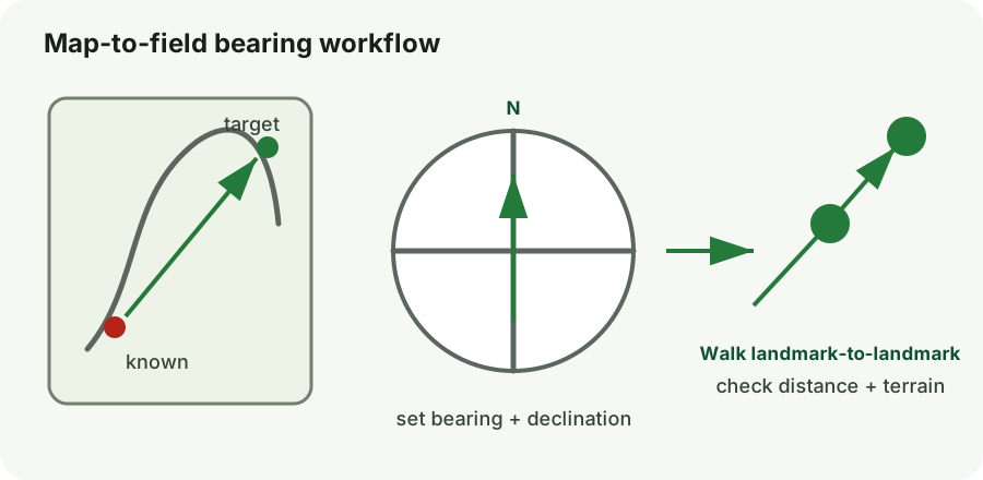
- Map to field: place the compass edge from your known point to destination, rotate the bezel so orienting lines match map north, then apply the local declination method for your compass.
- Field to travel: hold the compass level and rotate your body until the magnetic needle sits in the orienting arrow.
- Pick a landmark on the bearing. Walk to that object instead of staring at the needle while walking.
- Repeat in short legs. Reconfirm bearing after obstacles or direction changes.
- Track distance. Use elapsed time, known pace count, or mapped feature spacing.
Use terrain association and checkpoints
Rule: Build a route from unmistakable checkpoints so each leg verifies the previous one.
- Choose handrails. Roads, ridge lines, rivers, fences, coastlines, or valley edges can guide a leg.
- Choose attack points. Approach a hard-to-find destination from an obvious nearby feature.
- Choose catching features. Identify a large feature beyond the target that tells you when you have gone too far.
- At every junction: stop, point to the route on the map, and state the next checkpoint before moving.
- Record key turns. A quick note or photo of a junction can make return travel much easier.
Lost-route recovery and backtracking
Rule: The safest recovery is usually to reverse a known route, not to invent a new one.
- Return to the last certain point if safe and close. Use your own footprints, marked junctions, or unmistakable features.
- Do not split the group. Separation multiplies the rescue problem.
- Do not descend an unknown drainage simply because “water leads to people.” Cliffs, waterfalls, canyons, and floods can trap you.
- If recovery is not reliable, stop moving. Switch to shelter and signaling, especially if someone has your trip plan.
- Communicate any move. If you must relocate for immediate safety, leave/send the old and new positions and route when possible.
Practice before an emergency
- Orient a local topographic map outdoors without using the phone.
- Walk a short 3-leg compass course in a safe park and verify each endpoint.
- Estimate 100 m using pace count and compare with a measured distance.
- Plan one hike using handrails, attack points, and catching features.
- Practice the sentence: “last known point, next checkpoint, turnaround point.”
Use guides as references, not substitutes for training
Conditions, local law, official emergency instructions, product instructions, and hands-on training can change what is appropriate. When an emergency service or responsible authority gives you a specific instruction for the active incident, follow it.
Reference sources:
Source links are included so the guide can be checked against current official guidance. Review dates and local instructions before high-risk travel or seasonal hazards.
Related essential field guides
Additional procedures and printable references: